I just got back from Butte, Montana for our first ASM Teachers Camp under the Big Sky.
While there, we got to tour a couple of places that might be worth sharing.
On Monday night we took a
trolley tour of Butte from a
Butte High School history teacher,
Chris Fisk. Yes,
the Chris Fisk of '
saving a pig from Berkeley Pit' fame. (The tour was phenomenal, by the way. If ever you're in town, check the tours out. It was seriously outstanding.)
This post is going to focus on the portion of the field trip that visited the Berkeley Pit, an abandoned, open-pit mine that was operational from 1955 until 1979. For three years then, pumps kept water out of the Pit, water that would otherwise have filled the Pit and filled the various shaft mines loosely connected to the Pit, an interconnected honeycomb of mines that laced the ground underneath all of Butte.
 |
| The Pit as we saw it on 7/21/14 on a nearly windless day. |
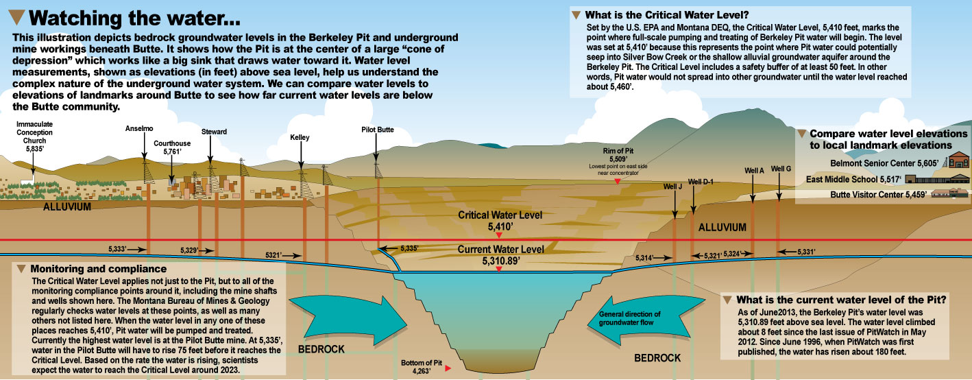
Then, in 1982 the pumps were turned off, and the Pit began to fill...and fill...and fill with water. The water continues to rise at a rate of eight to ten inches a month, headed for a water treatment plant that has already been built at an elevation of 5410' above sea level, the critical height at which water will start to flow
out of the Pit, contaminating the aquifer that is the source of Butte's drinking water. At that point, the water treatment plant will come online and maintain the water at a level just below that critical level...forever. As I write this, the water level in the Pit is 5318.01' (check current level here).
So, to our trip...(I warn you, there are lot and LOTS of photos after the jump.)
 |
| The entrance to the Berkeley Pit viewing stand |
 |
| The backs of our teacher campers at the viewing stand of Berkeley Pit |
 |
| one of four informational signs about the Pit on the viewing stand |
 |
| one of four informational signs about the Pit on the viewing stand |
 |
| one of four informational signs about the Pit on the viewing stand |
 |
| one of four informational signs about the Pit on the viewing stand |
 |
| the viewing stand above Berkeley Pit |
 |
| looking north-northeast from the viewing stand |
 |
| looking north from the viewing stand...notice the water treatment plant on the far right edge (with two dark green smokestacks) |
 |
| looking west-northwest from the viewing stand |
 |
| looking northwest from the viewing stand |
 |
| looking north from the viewing stand, across the Pit |
 |
| looking north-northwest from the viewing stand |
 |
| looking north across the Pit |
 |
| Google Maps's view down on the Pit (with my added labels in red) |
 |
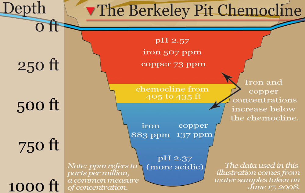
| from PitWatch, measurement of the water in various levels in 2008 |
 |
| also from PitWatch - history of the Pit's water level, how it's monitored and why |
|
Thanks to a few of our campers - Glenn Bradbury, Anika McCauley, Carissa Robinson - for sharing their photos. Sadly I don't know which are mine and which are theirs. Should've saved things a little different, I guess.
Sources for more information on the Berkeley Pit...

No comments:
Post a Comment